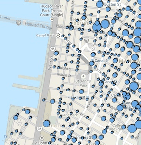
The NYPD and the Department of Information Technology and Telecommunications have fashioned an interactive crime map of the five boroughs.
Type in an address and you can see the locations of all reported felonies nearby for all months from January 2012 to October 2013, or you can see how felonies stack up by precinct.
“This administration has relied on data to drive its crime fighting, and this map helps enhance New Yorkers’ and researchers’ understanding of where felony and violent crime persists,” NYPD Commissioner Ray Kelly says is a release.
The NYPD is notoriously selective with its information—stonewalling Freedom of Information Act requests with impunity and playing favorites with whom it shares data. Last week, individual precincts were ordered to withhold weekly crime data that had traditionally been available to local reporters. So why did the police release this map?
Because they had to, per a City Council ordinance passed in the spring. Also, this data has been available on the NYPD’s website since 2003.
Gothamist’s crime map—which culls scanner reports to provide you an up-to-the-minute look at what’s happening around the city—is currently under repair. Look for our new and improved crime map in a few weeks.
Share this content:


